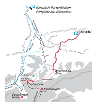
Ascents from Elmau Hotel
Please note that we won`t take any responsibility for the hiking times mentioned!
You can download and print the route sketches in the form of PDF files.
Ascent from Elmau Hotel via “Wettersteinalm” (“King`s Trail”)
(Duration 3½ hours approximately)
Starting from the Hikers car park (Wanderparkplatz) past Elmau-Hotel, you follow the “King's Trail”-signs (Königsweg) via “Wettersteinalm” to “Schachen”.
The trail is about 7 miles long and has a difference in altitude of about 2550 feet. This is the most well known and easiest ascent, very much appreciated by mountain bikers as well.
It should not be underestimated, however, since it contains some “tricky” sections. In particular the last part of the trail, having passed the “Schachen Lake” is quite strenuous and steep, even with scree …
Ascent from Elmau Hotel via “Wettersteinalm” and ”Schachentor” (“Schachen-Gate”)
(Duration 3½ hours approximately)
The trail starts at the Hikers Car park (Wanderparkplatz) near Elmau-Hotel and follow the so called “King's Trail” up to “Wettersteinalm”. From there, the path climbs steadily along impressive walls of rock up to the “Schachen-Gate” (mountain ridge).
Having passed this highest point, the path somewhat descends, and after one last ascent, leads you to “Schachenhäuser”, providing accommodation and meals. Nearby, you find the King's House, offering guided tours. This trail is somewhat shorter but more strenuous than the one described above.


